We'll start at San Antonio Spring where the river begins.
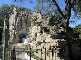
My neighborhood garden club recently enjoyed a guided tour of The Blue Hole. Blue Hole? This well-like stone structure houses the San Antonio Spring which is the headwaters of the San Antonio River. From this small spring the river flows south through the famous River Walk then another 250 miles to the Gulf of Mexico and the Aransas National Wildlife Refuge which is best known as the winter home of the endangered Whooping Crane.
The Blue Hole really does look blue. The water is very pure.
The property also incorporates a nature sanctuary in the city surrounded by the University of the Incarnate Word (UIW) campus. A non-profit organization called the Headwaters at Incarnate Word has recently incorporated to preserve the site and natural areas. Our guide Pam Ball (with map) discussed history and future for the site as part of the Sanctuary at Incarnate Word. The spring is considered sacred by indigenous peoples who still visit annually.
Until the early 20th century a 20 ft. high water spout marked the spring. As more people settled in San Antonio and drilled wells, the spring eventually lost pressure and became the gentle bubbler we observed on our visit. The spring is flowing nicely now due to plenty of rain. If this doesn't look like enough water to float those tourists boats along the River Walk you are correct. The San Antonio River is primarily fed by reclaimed water which was the subject of a previous post. Volunteers are helping to remove invasives and restore native plants to the site.
With Pam as our guide we walked past huge legacy oaks.
These trees have been documented for size and age though I don't remember exactly what Pam told us.

The Lourdes Grotto is part of the Sanctuary. Pam has removed invasive plants and planted drought-tolerant natives in front of the grotto.
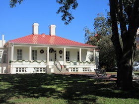
Pam told us he used to sit on his porch to watch the water spout from San Antonio Spring as a natural water feature for his property.
Now owned by the Sisters of Charity of the Incarnate Word the house is used for offices and meetings.
On the walk back to our cars we observed this palm growing out of the creek. This palm will be a reference point later.
The Headwaters Sanctuary is open to the public, however on weekdays you will need a temporary UIW parking pass (request one here) so it's best to go when classes are not in session or on weekends.
If all that planning is a bit much you can enjoy a walk along this same creek at Cathedral Park just behind the Headwaters Sanctuary and UIW campus. Cathedral Park is headquarters of The Episcopal Diocese of West Texas, which was a second destination I recently visited.
When the Blue Hole is flowing so is the creek at Cathedral Park. If you live in a rainy climate this may not seem like a big deal but the creek here is dry most of the time.

Our destination was a serene tree-house structure. The palm tree in the creek shown above is directly behind the condo building in the background.

Tree top views from the tree house and a built-in bird feeder on the right.
Cathedral Park is open to the public. I'll share more of my walk there in a future post.
Finally, we attended a "Partners in Conservation" event sponsored by San Antonio Water System (SAWS) at the Witte Museum just down the street from UIW and Cathedral Park. Here the San Antonio River flows through Brackenridge Park on its way south to the San Antonio River Walk.
One of the reclaimed water inlets is just north of the museum so there's a good bit more water in the river at this point.
We had a fun evening exploring the museum which was recently renovated. There's still a glimpse of an early building on the site where my great-grandmother and her sisters partied over 100 years ago.
The building houses an exhibit dedicated to early pioneers of San Antonio which was not open when we were there so I couldn't check to see if the bronze plaque with my great-grandmother's name is still there. Thank you to SAWS for a beautiful evening, it's nice to know our efforts at conservation are appreciated.
Three events, three different groups, all tied together by the importance of water in San Antonio.


Interesting information about the Blue Hole and the other water sources! We have fond memories of walks along the River Walk in San Antonio. I hope to get back down there one of these days. Wish I'd had more time before or after the Fling in May. I'm so glad I had a chance to meet you, though!
ReplyDeleteYes, it was fun to meet you finally and even more fun to see how much I already knew about you from your blog. Let me know if you come to San Antonio and I'll share more of my favorite spots.
DeleteThe Blue Hole and surrounding scenery are beautiful, Shirley. I'm impressed by how much San Antonio does to manage and conserve water sources. I can't make similar claims on behalf of the sprawling city of Los Angeles, although there is a LA River Revitalization Master Plan to guide the various public and not-for-profit agencies tackling segments of the 51-mile river.
ReplyDeleteThe more I learn the more I realize what a leader we are in the area of water conservation. Caring for our water supply has been important since before the Spanish laid claim to the area 300 years ago. At least they are trying a comprehensive plan in LA now.
DeleteVery interesting and beautiful. I'd no idea that the river was now mostly filled with reclaimed water.
ReplyDeleteDuring drought years the river would run dry and that would mean fewer tourists. Also reclaiming water is a good thing for our city and those to the south who depend on river water for agriculture.
DeleteWonderful to see such a gracious way of maintaining the water cycle. Cape Town is only just progressing from using that non-potable water for irrigating, to processing a good resource to be returned to the mains supply.
ReplyDeleteWater challenged cities should consider more uses. We produce so much reclaimed water it is used to irrigate golf courses and public landscapes along with filling the river. With all that, there's still enough left to go downstream for farmers.
Delete